Politics
Millions Brace For Catastrophic Weather Expected To Unleash Tornadoes On Eight States
Meteorologists are warning millions of Americans to brace for a dangerous storm system expected to sweep across a huge stretch of the country Friday, bringing the threat of tornadoes, damaging hail and hurricane-force wind gusts.
Forecasters say parts of Texas, Oklahoma, Kansas, Missouri, Arkansas, Iowa, Illinois and Wisconsin could be in the bull’s-eye as the system intensifies, with wind gusts potentially hitting 80 mph and storms capable of producing large hail and tornadoes.
The threat comes after severe weather already unleashed damaging winds, hail and tornadoes from Texas into Kansas through Thursday night. In northern Oklahoma, authorities said a mother and daughter were killed after powerful winds and a tornado struck the area.
Meteorologist Matthew Cappucci of MyRadar warned that Friday could deliver the worst impacts of the outbreak.
“Friday, March 6, 2026 could feature the season’s first widespread severe weather threat along I-35 in classic “Tornado Alley”,” he wrote.
“The main hazards are large hail up to hen egg size and damaging winds, but there’s a decent chance of some tornadoes too. If you have Friday evening/night plans, have a way to stay abreast of changing weather conditions.”
Forecasters said the severe threat remains at a Level 3 of 5 on Friday as the dryline pushes farther east across the central U.S. The risk is expected to increase as winds strengthen in the lower atmosphere, creating conditions that can help storms rotate and intensify quickly.
Winds roughly 5,000 feet above the ground are expected to strengthen north toward Kansas City and south toward Oklahoma City and Dallas, fueling the kind of instability that can produce fast-moving supercells.
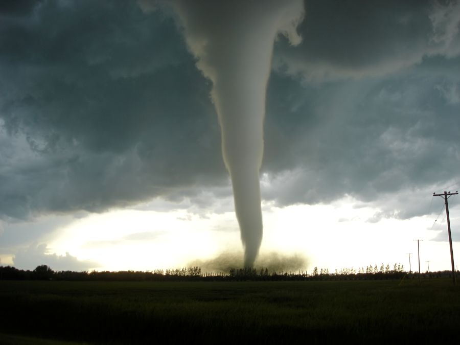
A large tornado was spotted west of Fairview, Oklahoma, and appeared to narrowly miss nearby areas. Local officials said the tornado may have produced EF3-strength winds, which range from 136 to 165 mph and are capable of causing severe damage.
AccuWeather warned its moderate-risk area Friday includes major metro regions such as Dallas, Oklahoma City and Kansas City, Missouri, with storms expected to push east toward Chicago by Friday night.
Forecasters expect two main storm waves Friday. The first could form mid- to late afternoon as a low-pressure system tracks across Kansas and the Missouri Valley, creating conditions ripe for supercells and very large hail.
Strong tornadoes may also develop Friday evening from Kansas City to Wichita to Oklahoma City.
Overnight, as a cold front pushes east and southeast, damaging winds, hail and tornadoes could stretch from Illinois down through Oklahoma into northeastern Texas.
The storm threat is expected to linger into Saturday. A cluster of storms could extend from southern Texas into western Tennessee and northwestern Alabama, with hail, damaging winds and flash flooding possible.
Farther northeast, forecasters also expect damaging thunderstorms from the eastern Ohio Valley into the Allegheny region of Pennsylvania and into western New York, with large hail, strong wind gusts and heavy downpours as the main threats.
Officials are urging people to have multiple ways to receive warnings, especially overnight, and to know where to shelter in advance. Mobile homes are especially dangerous in high-wind and tornado situations, and residents are encouraged to identify a sturdier shelter option before storms arrive.
Download the FREE Trending Politics App to get the latest news FIRST >>